
Halkyn Mountain
I took the road to Halkin; and immediately on quitting the town, began to ascend the steep slope of the county, fertile, and inclosed to the very edge of the mountain, which was parallel with the shore. The prospect improves the whole way; and from the heights expands to the north-east and south, into an almost boundless one. The estuary of the Dee appears beneath, with the city of Chester at its extremity. The peninsula of Wiral, a naked contrast to our country, limits the eastern side of our sea; and the western of the Mersey, rich in the commerce of Leverpool; beyond which stretches the great county of Lancashire, varying with plains and hills. The mountains of Yorkshire and Derbyshire unite to bound the VALE ROYAL of England; and the rich and wooded tract about Northop and Hawarden, with its neighboring mountains, bring relief to the eye, tired with the contemplation of the far remote views.
Thomas Pennant, A Tour in Wales (1778)
Halkyn Mountain is a place close to my heart and I have a strong emotional response to it. I love the open nature of the common, the fact that it is (nearly) always windy, and there are extensive views across Wales and into England. Plus it is full of evidence of people’s hard work and their lives through millennia, which, as an archaeologist, appeals!

John Ingleby, Moel y Gaer (1795). National Library of Wales.
I became very familiar with it through living on the edge of ‘the mountain’ for over thirty years. The first thing to say is that, to an outsider, it is quite unlike what an English speaker thinks of as a mountain. The Welsh word mynydd, as well as meaning ‘mountain,’ can also mean upland area, which exactly describes this space. I moved to Halkyn Mountain in the mid-1980s, from the south coast of England: my work colleagues, also archaeologists, knew exactly where I was moving to because its scheduled Iron Age hillfort, Moel-y-Gaer, had recently undergone extensive archaeological excavation. This gives a hint as to the depth of history of the place.
It is from the hillfort of Moel-y-Gaer that you get the most extensive views: it is like standing in the middle of a map. On clear days you easily see the Clwydian Range of hills, and the coast towards Talacre, but also across Liverpool Bay to Blackpool Tower, occasionally even the Isle of Man. In the opposite direction you look across the Shropshire and Cheshire plains towards the Peak District and to the north the Pennines, with sporadic glimpses of the southern Lakes. Thomas Pennant’s description, quoted above, captures it very nicely.

View from Halkyn Mountain to the Northeast (2016). Wikimedia Commons.
Halkyn Mountain is an Urban Common, which sounds counter-intuitive as it is a relatively sparsely populated upland open area. It is owned by the Grosvenor Estate (the Duke of Westminster) with around 200 households across the common having grazing rights, predominantly for sheep, although only a fraction of these exercise their rights to graze. There is a graziers’ association to which all 200 rights holders can be affiliated. The Common is just over 610 acres in extent and around 300 metres above sea level at its highest. It is classified as ‘open access’ land. The geology is predominantly limestone with some pockets of chert with lead veins criss-crossing the area. In the 1990s the area was identified as an outstanding historic landscape, which at the time was a non-statutory designation. In the early 2000s it became both a Site of Special Scientific Interest and a Special Area of Conservation, contentious designations at the time.
It is the history of the area, and particularly the lead mining here, which has led to its distinctive look and feel, and to its remaining largely unenclosed. The polluted soils have enabled rare plants like Spring Sandwort to thrive and great crested newts to find homes in and around the many ponds which link to the metal mining activity. These plants and newts are the reason it has one of the highest nature conservation designations, that of Special Area of Conservation.
The known history of the mountain, as it is still called by local people, goes back to the Neolithic period, around 5000 years ago. Traces of a possible house were found within the later hillfort during rescue excavations which took place before a reservoir was built within the hillfort. Ironically the building of the reservoir in a scheduled monument means that we now know far more about the site than we would have if there had been no building—and, because the reservoir acts like a giant header tank, the local village of Rhosesmor has good water pressure for their running water supply. The hillfort also houses a Bronze Age burial mound which is about 4000 years old, and the main structure itself dates back to 3000 years ago, with a series of three villages and fortifications, one on top of the other.
Lead mining started early on Halkyn Mountain. It was certainly exploited in the Roman period, as Roman lead smelters have been discovered in nearby Flint. A recent find of a unique Roman lead pig, found in the Rossett area and dating to the 60s CE is thought to be made from Halkyn Mountain lead. It was made at a time when Rome had not completely conquered north Wales, so perhaps hints at pre-Roman exploitation. The period of extensive castle building associated with the English King Edward I required large quantities of lead, and Halkyn provided some of this.
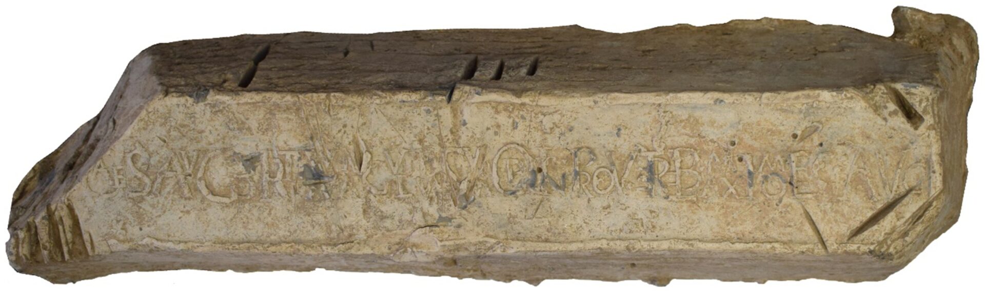
Roman lead pig (63–69 CE). Wrexham Museum.
But as you walk around Halkyn Mountain today it is the more recent remains of lead extraction that are most evident. The Grosvenors acquired the area through grants from the crown and an advantageous marriage in the seventeenth century and have taken royalties from both mineral and stone extraction ever since. In the late eighteenth and nineteenth centuries lead production increased and locally fortunes were made and lost. In 1715 extensive deposits were found in land at Pentre Halkyn owned by George Wynne of Leeswood: he brought in experienced miners from Derbyshire and there was a mini ‘lead rush’ which led to leases being granted to mines—even within Halkyn churchyard—and other locations on and around the mountain.

Moses Griffith, Halkyn Church (1770–1800). Wikimedia Commons.

George Wynne invested much of his profits into his country estate at Leeswood: no expense was spared. He erected beautiful Davies Brothers wrought iron gates at the entrance into his estate, and (although he died intestate and impoverished before he was 60), became Sir George, 1st Baronet, later an MP and High Sheriff of Flintshire. This investment of ‘new money’ into local country estates was repeated over again, with many local estates like Gwysaney and Penbedw undertaking refurbishment of both houses and perhaps particularly, their gardens and parklands: this was the period when many landowners were ‘upgrading’ to a picturesque landscape. The Duke of Westminster himself was not immune, developing a racecourse and stables in the area in the late eighteenth century, before building Halkyn Castle close to Halkyn Church. Indeed, he demolished the medieval church and part of the village to ensure the privacy he wanted. He paid for the rebuilding of Halkyn Church, donated land for a school (as his successor did again in the 1950s when a new school was built on the mountain) and for a Parish Hall.
The landscape of Halkyn Mountain is very distinctive. Bleak and barren to some, it is fascinating to me, and full of hints of its mining past. In places it evokes an almost lunar landscape of lumps and bumps, spoil heaps and mineshafts, capped or not. It encapsulates its own past history, but also makes us think about the wider development of the picturesque and the ‘home improvements’ of the local gentry in the late eighteenth and early nineteenth centuries. Recently there have been proposals for a National Park designation in north-east Wales. At its core is the existing National Landscape of the Clwydian Range and Dee Valley. Halkyn Mountain has also been considered, but is currently excluded—partly because it is an area with active quarrying, but also because it is not considered ‘beautiful,’ or meeting criteria for National Parks. There are ironies here, when we remember that this very industry, including the modern-day quarrying, has helped to finance the development of many local estates and grounds—those very places we consider so ‘beautiful’ and ‘picturesque’ today. Halkyn Mountain is a strange and unique place, and its historically loaded landscape is every bit as worthy of special protection.